
Sometimes, the Auckland Council does some very good things. The new plan for the city centre and waterfront, says Simon Wilson, could just be one of them. Although it does have a few problems…
Auckland councillors did something a bit unusual the other day: they gave council officials a standing ovation. (Well, that’s what a couple of the officials told me.) Why the lovefest? Because the officials – drawn from the core council, Auckland Transport, Paunuku Development, ATEED and others – had produced a new version of the City Centre and Waterfront Masterplan. And the councillors liked the way they had worked so well together and, besides, they thought it was a very good plan.
Planning committee chair Chris Darby says “a political pleasure” pervades the council. Is it justified?
Some of the details of the plan have already been made public, but there’s a lot that’s new, and the big news, in terms of progress, is that a budget timetable has now been established. This isn’t a “nice to have” piece of planning hopefulness.
It’s a construction schedule.
Parts of it are already underway and much of it will be finished by the time America’s Cup fever hits town at the end of 2020. The plan goes to the council’s planning committee this week and then will be folded into debate about the 10-year budget. That will be adopted in draft form later this year and go out for public consultation early in 2018. The key features of the new City Centre and Waterfront Masterplan are:
On the downtown waterfront
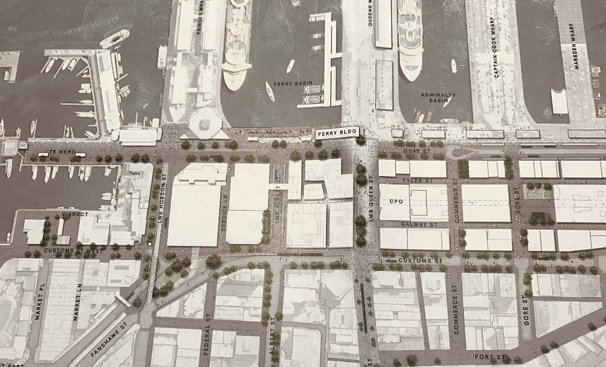
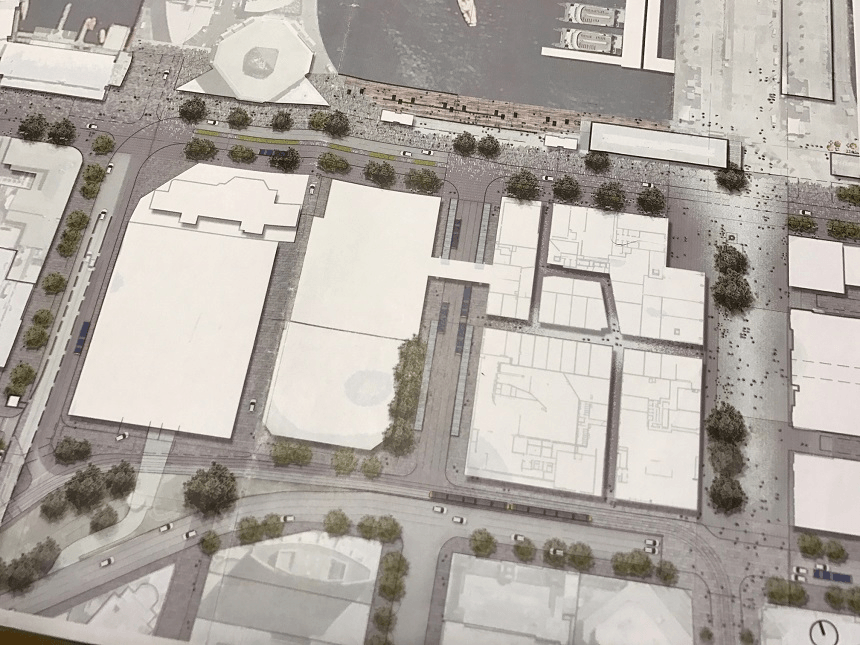
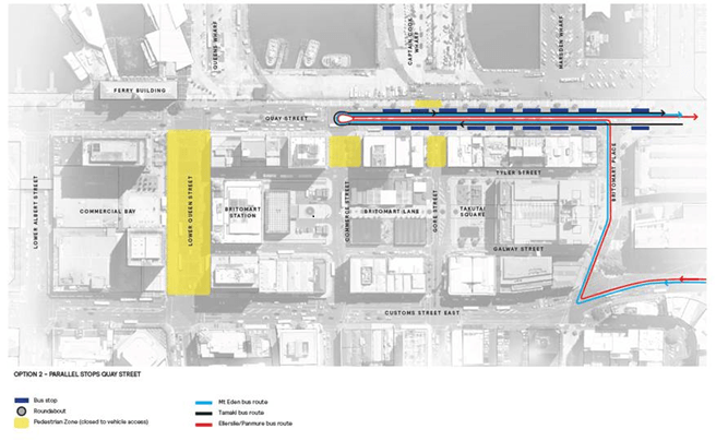
- A new major T-shaped pedestrian plaza in front of Britomart Railway Station and to the east and west on Quay Street.
- A new terminal on Quay Street for buses from the east, and another new terminal at the bottom of Albert Street for buses from the north.
On the wharves
- A new seawall in the Ferry Basin, along with a new promenade at the water’s edge and new ferry terminals.
- Extension of Captain Cook Wharf.
- Cars gone from Captain Cook Wharf and a new cruise ship terminal based there.
- Removal of Marsden Wharf.
- Development of Queens Wharf.
In midtown/at the universities
- A major new bus station for the University of Auckland.
- The transformation of Wellesley Street and Victoria Street into “two great streets”, with Wellesley Street being the major east-west bus route and Victoria Street becoming a “linear park”.
- Introduction of “rapid transit” (light rail, although the government won’t say it yet) from Wynyard Quarter and up Queen Street.
- Gradual pedestrianisation of blocks of Queen Street.
On the western waterfront/Wynyard Quarter
- Removal of parking from the northern arm of the Viaduct and a new footbridge across to Wynyard.
- A new plan for the Tank Farm, including a big park suitable for events like the Laneways music festival.
- New facilities for the America’s Cup.
- No Sydney Opera House. Or any other big new public building.
What’s driving this?
The council needs to get cracking. It’s got a 10-year budget to create, consult on and sign off over the next 12 months: work has already started, and the new plan proposes when and how the budget requirements can be enabled.
The council has to get the construction timing right, too, so that everything aligns with construction on the City Rail Link (CRL). It also has to synchronise with the rapid progress of what will become Commercial Bay: that massive hole in the ground opposite the front of Britomart.
Nobody wants streets dug up twice.
We need this rethink because the city is growing fast. There are now 120,000 people working downtown and 45,000 living there: that’s a target the planners in 2012 did not expect to hit until 2032. We have 100,000 students, and on any given day about 20,000 visitors.
Conversely, traffic numbers in the central city have fallen – in part because of the CRL disruption. But pedestrian numbers have ballooned. That’s important: despite the central city being busier than ever, people are not driving in as much as they used to. The city is changing.
And there’s the America’s Cup, coming right at us in the summer of 2020/21 and followed directly after by a whole year of APEC meetings. The council will have to do far more than build some yachting facilities. Both the Cup and APEC challenge the city to create a modern and highly functional public transport system – to cope with the crowds, obviously, but also to provide the city with services it needs anyway.
They also provide opportunities for entrepreneurs and for so many others, in employment, in education and training, in the way Auckland works and the way we live and work in it.
This is what cities use big events for, or try to: making themselves better places. Mayor Phil Goff has talked about the legacy potential of the America’s Cup, and this is it. Get the transport sorted; get the downtown blooming; make Auckland a place where talent prospers and opportunities abound.
Viv Beck, CEO of the business association Heart of the City (full disclosure: they help fund The Spinoff’s Auckland coverage), says one of the key achievements of the new plan is the way it integrates transport with everything else. That hasn’t always been evident – witness the dispute between Auckland Transport and the core council over Victoria Street, and the council’s fight with Ports of Auckland over expansion into the harbour. Those things are now resolved.
“There has been no shortage of aspirational plans for the concentrated area around the CBD,” says Beck. “However, up until now what’s been missing was how public transport fitted into these plans.”
Importantly, the city centre plan is not just a plan for the city centre. Ferry patronage is on the rise, especially from places like Hobsonville, but right now there isn’t the berth capacity to introduce many more ferries. If you catch a ferry from Stanley Bay at peak time, you’ll take seven or so minutes to get across the channel and perhaps another 10 waiting to berth.
The new plan allows more ferries and more buses to operate, which increases the frequency and therefore the value of the new transport services planned for the outer parts of the city.
If you live in Howick, think of it this way: they can put on more buses to get you into town. If you live in Devonport or Belmont, more ferries will mean fewer cars in the morning peak trying to get up Lake Road.
Breaking it down: the waterfront
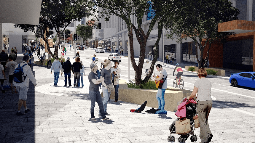
By early 2019, Commercial Bay in front of Britomart will be a giant complex of shops, bars and restaurants, with laneways running through it to connect with the new bus terminal at the bottom of Albert Street. (The first part of the development will open midway through next year.) The plaza area around it, on Queen Street and Quay Street, is expected to become a new heart in the city, with just a single lane of traffic each way on Quay Street and most east-west traffic directed to Customs Street, which will be two lanes each way.
The seawall at the head of the Ferry Basin is being renovated, and a new promenade deck will be built. The ferries themselves will have new space-efficient berths, in a row along the eastern side of the basin. New York ferries are berthed in the same way.
The red fence will come down all the way along to Bledisloe Wharf, and Captain Cook Wharf will become public space. An extension is proposed, taking it out to the length of Queens Wharf to accommodate cruise ships on both sides (when there’s a third in port, it will berth at Princes Wharf).
The Cloud will be removed from Queens Wharf, although the timing is unclear. The Cloud was a pet project of former Rugby World Cup minister Murray McCully, who is going but not gone yet. After the election, a decision is likely. The plans also show extra buildings on Queens Wharf: this could mean the return of Shed 11, the companion to Shed 10 that was torn down to make room for the Cloud. It’s in storage, each piece numbered and awaiting reassembly.
The pedestrianisation of Quay Street and the area along the water’s edge will transform the waterfront into a wide recreational boulevard (and yes, with cycle lanes). Buses coming in from the east will turn on a loop opposite the bottom of Commerce Street, with a big new terminal stretching east along Quay Street to Britomart Street, at the far end of the Britomart complex.
Will there be swimming? Quite possibly, and probably there will be steps down into the water, too, as at Karanga Plaza in the Wynyard Quarter.
And the imported cars? Ports of Auckland plans to build a parking building for them. Hallelujah.
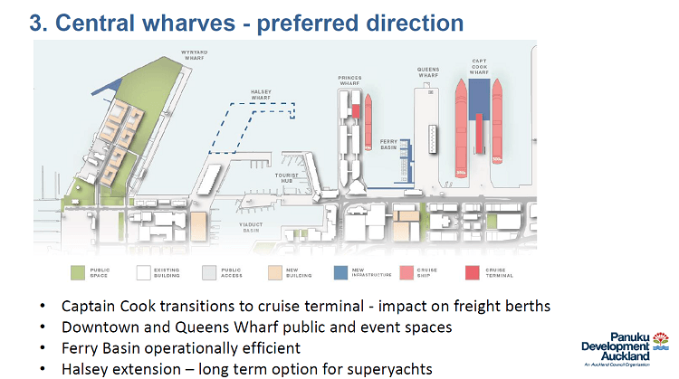
It’s not going to be without controversy. The plan is to remove the smallest finger wharf, Marsden Wharf. It’s already half demolished, and this will make room for cruise ships on the east side of Captain Cook.
But for those cruise ships to berth the plan also proposes to extend Captain Cook out roughly in line with the end of Queens Wharf and Princes Wharf. Is that acceptable? It doesn’t encroach on the harbour in any meaningful way but it is a reclamation. “On balance,” Cr Darby says, “it’s a good outcome.”
The promenade at the head of the ferry basin will also encroach over the water, either as a platform or as reclamation. Is that acceptable?
Breaking it down: midtown
Auckland gets the linear park along Victoria Street, connecting Albert Park with Victoria Park. This, in theory, is a magnificent triumph of inspired design and public opinion: submissions to Auckland Transport over its attempt to scrap the park that runs along the street overwhelmingly favoured the park.
In practice, the concept drawings, by architectural firm Jasmax, don’t really show it as a park. There are a few more trees, and much bigger walkways, but the street has not been greened. Just going to say this, Jasmax and council planners: a park is a PARK. It’s green. The council knows exactly what I’m talking about because they’re already done it along Daldy Street in the Wynyard Quarter. The drawings they’re using for Victoria Street need to be abandoned so the potential of the concept can be properly grasped.
Some traffic will still use Victoria Street, but most of the buses will be routed along Wellesley Street. That street will also be very pedestrian friendly – it has to be, it’s going to have the main entrance for the Aotea metro station. 20,000 people a day are expected on that street, so the walkways will be wide and safe and the road will not, as one planner said to me, be “a bus sewer”.
Up at the universities they’ll build a big new station just past the Symonds Street underpass. The University of Auckland will put a “gateway building” over it, much as Manukau Institute of Technology sits over the Manukau Railway Station.
The council isn’t going to spend money on this: it’s an opportunity for a developer and/or the university itself.
And the big prize, light rail? The council’s plans show it starting in Wynyard, snaking across to the city centre and running up Queen Street. Officially they’re calling it “rapid transit” (that is, it could be a bus) because that’s as much as the government has been prepared to commit to. But nobody should be fooled: this will be light rail and in time it will reach the airport.
If they start soon, they’ll have it running up Queen Street and down Dominion Road in time for the America’s Cup. The Greens believe it could be pushed all the way to the airport by then, an obvious enormous benefit for 2021. If that party forms part of the government we’ll find out soon enough if it’s possible.
Light rail will probably also lead to the pedestrianisation of Queen Street. They’d do it together.
Breaking it down: Wynyard Quarter
Personal disappointment: they’re going to demolish the Wynyard Crossing, the footbridge from Te Wero Island to Karanga Plaza. But I get it. The maintenance costs are building up: that bridge was built in 2010 for a five-year life and it carries two million people a year. It will be replaced with something similar but more robust.
As for the absurd car park on the northern arm of the Viaduct, that’ll be gone later this year.
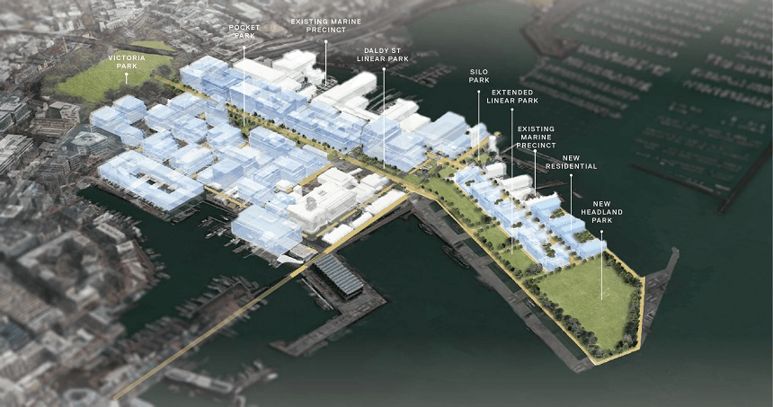
The bigger issue is what happens on the Tank Farm, which the council seems determined to call Wynyard Point park. Good luck with that. The council wants a big open parkland at the northern end, fringed all round with trees.
From there, the city’s new great linear park would begin, running down the eastern side of the peninsula, up Daldy Street to Victoria Park and from there into the city centre along Victoria Street and up to Albert Park. A great long walk and cycleway.
Silo Park would be built up on its west side, with marine precinct and residential buildings. This is the east/west inverse of the Unitary Plan and will require a plan change.
No great public cultural building is proposed. Cr Darby says they’ve been consulting cultural institutions and other groups and no one has the money or the will to lead a campaign to put a signature building on the waterfront, either at Silo Park or anywhere else.
Instead, the hope is to configure the ground floors of the buildings that do get put up on Silo Park, so that they offer a range of cultural activities. Galleries, studios, performance spaces, perhaps.
Frankly, this feels a little like giving up. Before we even barely get started.
As for the America’s Cup itself, it’s possible they’ll propose an extension to Halsey Street Wharf, but nothing specific is yet definitely in the plan. The council won’t know what’s required (or even if Auckland will definitely host the event) for a couple of months. But they’ve set out eight criteria the Cup campaign will need to meet and set up a working group with Emirates Team New Zealand and government representatives. That group is led by council CEO Stephen Town and has just started to meet.
How good is the future?
The new version of the City Centre and Waterfront Masterplan is built on the principle that the city should develop really good versions of absolutely doable things. No big new projects, unless they are transport projects, no new museum either for general cultural purposes or specifically related to mana whenua.
You get more done this way. Iconic buildings are so 20th century. That’s the thinking. But is it true? Doesn’t Auckland really need a great beacon on its waterfront, a museum of Pacific technology, perhaps, celebrating all the voyages from the earliest arrivals to the exploits of the America’s Cup itself? Or a museum of Tāmaki Makaurau, all the history and future you could pack in?
And even with the “lots of little things” approach, we still need better versions of those things than is suggested by the Victoria Street drawings.
There are also questions of funding to work through. The plan sets out a sequence of budgeted (rates) spending, but there will be other money involved too: Viv Beck of Heart of the City says some “lateral thinking” is needed, and notes that that targeted rate paid by businesses in the central city will contribute to some of the projects. “But,” she says, “the way central and local government work together and with the private sector will be vital.” As always, ain’t that the truth.
But leave all that aside, just for the moment. The plan sings with possibility. Public transport, functioning well and set up to grow, and fully integrated, finally, into the rest of the planning in the inner city. Decisive steps to open the waterfront for greater public use. Excellent integration of transport modes and servicing of population hubs like the universities. The greening of the central city and its steady conversion to a pedestrian wonderland, bursting with shoppers, workers, students and visitors, bursting with opportunity.
simon@thespinoff.co.nz @simonbwilson
The Spinoff Auckland is sponsored by Heart of the City, the business association dedicated to the growth of downtown Auckland as a vibrant centre for entertainment, retail, hospitality and business.