

The City Rail Link could have been an opportunity to rejuvenate one of Auckland’s most unlovely thoroughfares. Instead, Albert St seems likely to end up looking worse than before, writes Matt Lowrie of the urban design blog Greater Auckland.
Last week in the Herald Simon Wilson lamented the mess that has been made of Albert St’s reinstatement as part of the City Rail Link project, something we here at Greater Auckland have long been concerned about. Wilson’s noted that the City Centre Advisory Board (CCAB) had expressed their deep disappointment with the designs for the street, especially the lack of greenery and the inclusion of unnecessarily long bus bays along large stretches of the road.
“Why so upset? Because the board gave City Rail Link Limited (CRLL) $20 million of business ratepayers’ money to fix Albert St. Because the CRLL plan showed it looking worse than it used to be, with no trees in the top half, lots of roadway for buses and cars, and lots of bays for buses to park in…
“Albert St’s new footpaths will be wider, but despite that it’s a bleak, featureless landscape. Right by the Wellesley St and Victoria St entrances to the CRL’s new Aotea Station, where tens of thousands of people will walk to and fro each day.
“The street was almost destroyed by the CRL build. But the thing is, with most of the traffic gone, new possibilities now beckon. We’ve discovered the city functions just fine without Albert St being an ugly dead zone, so why turn it back into one?
“The strategy for making good in the inner city in the wake of CRL construction (and light rail too) should be: use the disruption to establish new and better functions and features. Less transit route-focused and more pedestrian-focused, more shopper-focused. Better streets to be in.”
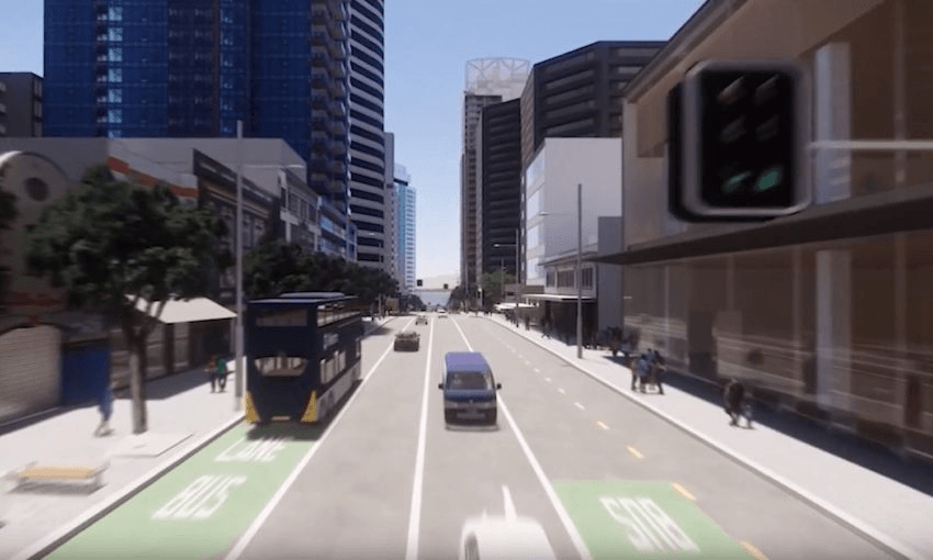
You can see the design in this recent video which we covered just over a month ago:
While there’s a lot to be excited about with parts of this video, like the cool entrances to Aotea Station, you can see the issue with Albert Street and the impact of very long indented bus stops. They end up making the road corridor very wide in what is a critically important pedestrian area:

I think the CCAB’s disappointment is well justified, if for no other reason than that the City Centre Targeted Rate is meant to be for improving the city, not just to return it to same state it was in before the CRL started. Here’s how Heart of the City describe the rate:
“This generates around $20 million each year – and these funds are used to upgrade and develop the city centre with projects like the shared space programme and public space upgrades like St Patrick’s Square and Freyberg Place. These projects bring to life the City Centre Masterplan – which recognises the role that the city centre plays as the economic engine for Auckland and the whole of New Zealand. In order for the city centre to remain vibrant and successful and to accommodate the anticipated growth, ongoing investment into the public spaces and transport infrastructure is needed. The investment seeks to significantly enhance the city’s public spaces to make them more people friendly as well as encourage further private sector investment.”
As a comparison, here’s what this section of Albert St looked like before the CRL works started. There were even more trees then:

What’s proposed is even noticeably different from the concept design which I think was used to help get the CCAB to approve the use of the targeted rate funding. This is the same section and while some artistic licence has been taken with the scale of the trees, it clearly shows them in place of the bus bays:

The lack of trees in particular is noticeable in other parts too. For example the section just north of Victoria St goes from having at least some green…

…To being almost completely barren. This is also where, brick by brick, they’re going to shift the historic bluestone wall to gain some extra space. I might not mind so much if it meant we got an exit on the northern side of Victoria St, the lack of which I think is a serious omission. Related, does anyone know what are those triangular things in the middle of the footpath are for? Station ventilation?

Simon Wilson’s article jumps in and blames the engineers for this poor design outcome:
“My guess: Albert St was visualised by traffic engineers who don’t listen to a word urban planners say; but Wellesley St is merely a concept right now, so it was visualised by designers who have not yet been crushed underfoot by engineers.”
We don’t hold back in our critiques of transport engineers, but in this case I think the issue is more one of silos and various parts of Auckland Transport not keeping up with big picture strategic transport changes that have taken place over the past year. In particular, Albert St was to be the city end of the Northwest Busway before the new government adopted our suggestion from the Congestion Free Network that we should instead be looking at light rail for this rapid transit corridor.
Detailed analysis of city centre bus operations highlighted several issues with feeding large bus volumes into Albert Street in the future. Its capacity was assumed to be exceeded by 2026 and under very significant strain by the mid-2030s.

This led AT’s bus operations teams to demand that Albert St be able to accommodate more than 70 buses an hour to maximise the chances of maintaining an efficient busway at its city end. It’s not clear why the bus stops that the bays serve are even there in the first place. It’s worth remembering it’s been a few years since we last had buses on Albert St north of Victoria St and it will likely stay that way till around 2023/24 when the CRL is completed. The focus should be on having people use stops near Britomart or Wellesley St; AT’s own design standards say they shouldn’t be used (page 43 of this doc). As I understand it, the way the CRL delivery has been set up, even when it was still under AT, they weren’t allowed to push back on the demands – so we’ve ended up with this compromised outcome.
Note: I understand the need to accommodate these bus volumes has also been a factor in the in the delay to the improvement to Karangahape Rd project.
Light rail makes the whole issue irrelevant anyway.

Unlike the Northwest Busway, a Northwest light rail line would simply link into the City Centre-to-Mangere light rail line somewhere near Upper Queen St, with both running down Queen St. This would remove a large chunk of the buses from Albert St. While some buses would still need to run on it (those serving the inner west), the volumes would be vastly lower than if the whole Northwest Busway was plugging into Albert St. For Queen St it would still be only a light rail vehicle every few minutes, leaving plenty of time for pedestrians to cross.
It comes down to this: there really isn’t a need for a five-lane wide Albert St anymore. Auckland Transport needs to wake up and realise times have changed, the busway will not be happening and Albert St does not need to be a vastly wide bus corridor. Why they haven’t yet realised this isn’t just an open question, it’s a debacle.
This article was first published on the Auckland transport and urban design blog Greater Auckland.
The Bulletin is The Spinoff’s acclaimed, free daily curated digest of all the most important stories from around New Zealand delivered directly to your inbox each morning.