

The Kaikoura earthquake lifted long strips of coast out of the sea on Monday morning, in parts as high as two metres. Ursula Cochran and Kate Clark of GNS Science and Sharyn Goldstein of the University of Canterbury explain what’s going on.
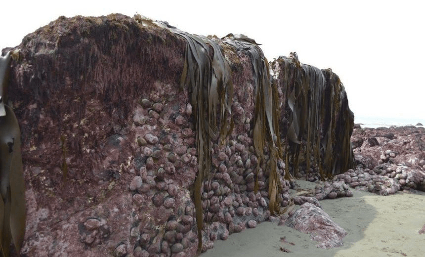
Much of the northeastern coast of the South Island was uplifted during the 14 November earthquake. We know this from photos of rock platforms covered in seaweed and marine animals such as crayfish and paua stranded above tide levels. Our records measured the tide gauge at Kaikoura was lifted up by one metre, and continuous GPS monitoring sites at Kaikoura and Cape Campbell were also raised by 0.7-0.9 m. At this stage we can estimate that the coast was raised between 0.5 m and 2 m from about 20 km south of Kaikoura all the way north to Cape Campbell. Scientists plan to find out more about this coastal uplift.
The whole seabed raised out of the ground #kaikoura #eqnz #earthquakenz pic.twitter.com/CbUVW5YjX2
— Lou (@lou_gordongreen) November 14, 2016
What is coastal uplift?
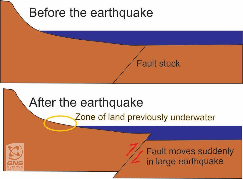
Coastal uplift is when the land is raised above the sea by tectonic forces. It can happen gradually over geological timescales or suddenly by an earthquake.
How does it happen?
Sudden coastal uplift happens as the result of large earthquakes. Vertical movement on a fault can cause land to be pushed up. This is the type of movement that has built many of the mountain ranges in New Zealand. When such vertical movement on a fault happens near the coast, land is raised above sea level. Sea level is a powerful horizontal marker for measuring tectonic movement because it is very obvious which land used to be underwater before the earthquake.
Kaikoura coastline before and after the earthquake pic.twitter.com/nmV8KEnuug
— Philip Fierlinger (@skyrize) November 17, 2016
Is coast uplift normal?
Coastal uplift is normal for large earthquakes near the coast that include some vertical movement on a fault. Most movement on the faults that ruptured in the Kaikoura M7.8 earthquake was horizontal, but there was some vertical movement too, so it is not surprising that there has been some coastal uplift from this event.
In New Zealand there is evidence preserved in the landscape that shows many parts of the coast have been repeatedly uplifted through time. For example, raised marine beaches and terraces along the Kaikoura Peninsula, Wairarapa coast, Cape Kidnappers, Mahia Peninsula, north of Gisborne and East Cape, are evidence of former beaches that were uplifted from the sea by earthquakes in prehistorical times. Many of these have been or are currently being studied to find out the size and age of past earthquakes.
Historical examples
In historical times we have had several examples of earthquakes causing coastal uplift that, although devastating in the short term, have led to some benefits. For example, in 1931 the M7.8 Hawkes Bay earthquake raised land around Napier by 1-2 m above sea level. Land that used to be estuary now provides space for Napier airport. In 1855 the M8.2 Wairarapa earthquake raised much of Wellington by 1-2 m. The road from Wellington city to the Hutt Valley became viable as a result of the new land around the harbour’s edge.
Aerial photographs show the seabed uplift north of Kaikoura – estimated to be between 2 – 2.5 metres. #EQNZ pic.twitter.com/WLkSj4Xx9m
— Tonkin+Taylor (@TonkinTaylor) November 15, 2016
Will the land go back down?
Probably not. The newly raised coastline of the Kaikoura coast is most likely a permanent feature. Historical and pre-historical examples show that in many parts of New Zealand these raised beaches remain high above sea level. However, in some parts of the world, raised beaches have been known to gradually drop down again (over centuries) or be dropped down suddenly in a large earthquake with a different sense of movement.
What will happen to all the sea creatures?
There will be a major shift in the community of marine species. Many seaweeds and animals that would normally be permanently covered by water will now be struggling to exist in a zone of transition between air and sea. Some of the animals that have been raised will be accustomed to air exposure for short periods of time, but not the full tidal cycle that they will now experience. As the animals not suited to this environment die from the reef, they will be replaced by seaweed and animals appropriate for the new tidal level.
What are scientists doing to study the coastal uplift and its impact?
There are several studies being planned by geologists and biologists. Over the next weeks and months geologists will be undertaking surveys along the coastline to measure the amount and extent of coastal uplift that has occurred. Recording this information will help us to understand which faults ruptured in the earthquake, and how much slip occurred on those faults. Over the coming weeks marine ecologists and fisheries scientists will be surveying areas on the rocky shore to understand the sequence of change. The surveying will continue for in the long-term for changes to be captured.
This post first appeared at GeoNet
The Spinoff’s science content is made possible thanks to the support of The MacDiarmid Institute for Advanced Materials and Nanotechnology, which is a national institute devoted to scientific research.