


Geonet has released newly calculated aftershock probabilities that put the chance of one or more M6-6.9 quake in the next day at 37%.
Rapid field reconnaissance indicates that multiple faults have ruptured:
- Kekerengu Fault at the coast – appears to have had up to 10m of slip
- Newly identified fault at Waipapa Bay
- Hope Fault – seaward segment – minor movement
- Hundalee Fault
In the simplest case an earthquake is a rupture on a single fault plane.
What we are finding in New Zealand is that quite a few of our larger earthquakes involve jumping from rupture on one plane to another in a complex sequence. We first saw that with the Darfield September 2010 quake where multiple segments ruptured together as a single earthquake. We appear to have seen this again.

In terms of what might happen next: The scenarios below provide an overview of how we see this earthquake sequence evolving over the next few days to one month, based on the best information that we have to hand at the moment. As our science information flows in over the next few days we expect that information may evolve.
Scenarios and probabilities
Most earthquake aftershock sequences decay over time, with spikes of activity and occasional larger earthquakes. We have updated our probabilities of larger or similar sized earthquakes; we use probabilities as we cannot predict earthquakes. The probabilities in the table below describe the likely progression of the sequence within the next day, week and month. The scenarios specifically address what we expect within the next 30 days, however, we expect aftershocks to continue for months to years.
Most earthquake aftershock sequences decay over time, with spikes of activity and occasional larger earthquakes. We have updated our probabilities of larger or similar sized earthquakes; we use probabilities as we cannot predict earthquakes. The probabilities in the table below describe the likely progression of the sequence within the next day, week and month. The scenarios specifically address what we expect within the next 30 days, however, we expect aftershocks to continue for months to years.
The scenarios: There are very different probabilities for each scenario; some of these are more concerning than others. We recognise that while these scenarios may increase anxiety the best thing is to be prepared. Remember: If you feel a long or strong earthquake and you are on the coast, evacuate immediately.
We’ve developed three scenarios based on what we know so far but be aware that our understanding is evolving as we do more analysis and receive more data.
Scenario One: Extremely likely (>99% within the next 30 days)
The most likely scenario is that aftershocks will continue to decrease in frequency (and in line with forecasts) over the next 30 days. Felt aftershocks (e.g. over M5) would occur from the M7.5 epicentre near Culverden, right up along the Kaikoura coastline to the Cape Palliser/Wellington area. This includes the potential for aftershocks of between 6.0 and 6.9 (91% within the next 30 days). Scenario one will continue to play out, even if either scenario two or three also occurs.
Scenario Two: Unlikely (15% within the next 30 days)
An earthquake smaller than Monday’s mainshock and between M7.0 to M7.5. There are numerous mapped faults in the Marlborough or Cook Strait areas capable of such an earthquake. It may also occur on an unmapped fault. This earthquake may be onshore or offshore but close enough to cause severe shaking on land. This scenario includes the possibility of an earthquake in the Hikurangi Subduction Zone. Such earthquakes have the potential to generate tsunami.
Scenario Three: Very unlikely (7% within the next 30 days)
A much less likely scenario than the previous two scenarios is that recent earthquake activity will trigger an earthquake larger than Monday’s M7.5 mainshock. This includes the possibility for an earthquake of greater than M8.0, which could be on the ‘plate interface’ (where the Pacific Plate meets the Australian Plate). Although it is still very unlikely, the chances of this occurring have increased since the M7.5 earthquake.
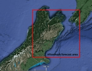
Within this sequence, aftershocks will most likely occur anywhere in the box on the map (see image). It is this geographical region for which the modelling is done. It is important to understand that earthquakes can and do happen outside this box but the box represents the most likely area related to this sequence.
Aftershock Probabilities for the area outlined in the map below
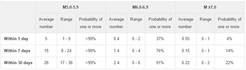
For example there is a 37% chance of one or more M6.0-6.9 earthquakes occurring within the next day. We estimate there will be between 0 and 2 earthquakes in this magnitude range within the next day.
Forecast for rectangular box with the coordinates -40.7, 171.7, -43.5, 171.7, -43.5, 175.5, -40.7, 175.5 at 12 noon, Tuesday 15 November.
* 95% confidence bounds.
Tsunami
Our earliest reports are that there is only a little bit of tsunami damage on the coast. Happily, it is not as much as we were expecting. However, further impact assessments need to be performed before we can conclusively say this for the whole East Coast.
Landslides
We are roughly estimating from yesterday’s reconnaissance flights that there may have been from 80,0000 to 100,000 landslides. Much of the area affected by landslides is in the remote and rugged areas of the Inland and Seaward Kaikoura Ranges. Satellite imagery from both before and after the earthquake is currently being sourced. This will allow a change model to be developed telling us where the landslides have occurred. This will likely take at least two weeks, if not longer because acquiring cloud-free imagery after the earthquake takes time.
The reports of landslide dams points to a potential developing hazard. Landslide dams can last thousands of years, they can fail slowly or they can fail very quickly. When they fail very quickly they can release large volumes of water and sediment into river systems as a flood wave (flash flood). These floods can be hazardous to river users and we would ask people to stay away from the all rivers on the east coast of the South Island from the Hurunui to the Awatere until inspections have been completed and more precise information can be provided.
The landslides that have occurred as a result of the earthquake remain dangerous. Material can move at any time. Please exercise caution when in the vicinity of landslides and cracks in the ground on slopes. If it is raining the threat rises as the water can remobilise the debris as debris flows and debris floods (flash floods). Please avoid landslides in wet weather.
For more on the above animation, see here.
A word about other theories
We understand that a “super moon” is going to happen tomorrow night. However, we only report on information and correlations that can be verified through our instruments and backed up by our friends at the USGS.
The above is based on the latest Geonet post from Sara McBride; it updates earlier information summarised here.